The Bagaces Side of Miravalles


Our first ever visit started out from Fortuna de Bagaces (not the Arenal La Fortuna) and was one of the most memorable days of hiking we ever enjoyed.
Our friend The Priest (his name is Climaco but The Priest is what his family and friends call him) gave us the keys to his Suzuki Samurai, introduced us to the teenage daughters of his maid and told us they would be our guides for the day.
It was 1993, we were on our honeymoon, the girls were bored, it was Christmas day and The Priest didn’t have time for us – so off we all went with to explore a waterfall they knew on Miravalles Volcano.
On the way up to the ranch where the trail started the girls quizzed us about the meaning of Michael Jackson’s Billie Jean which they had blaring full volume on the tape deck over and over. They didn’t get far because none of them spoke English and we hadn’t started to learn Spanish, and well, explaining Billie Jean to teenage girls is just hard anyway.

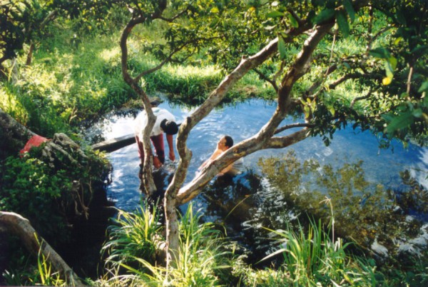
The waterfall was incredible as you can see from the grainy old scanned in film photograph and we had a blast (as you can also see). On the way down the girls tried to convince us the best way was to just sit in the river and let the current carry you along.
That would have been fine but the water was only 12″ deep in most places and I thought for sure I’d broken my tailbone repeatedly. They must have had years of training and secret techniques because they were laughing the whole time.
Afterwards we walked to a little natural hot spring where the school kids liked to hang out and soaked our aches away.
I can’t say for sure we were in the National Park (pre GPS days), in fact I don’t think the National Park was even declared yet, but we were definitely on Miravalles Volcano. The girls are grown up, married and have kids almost as old as they were when we hiked together and The Priest was relocated to Sardinal so we don’t get over to the Bagaces side much anymore.

The Bijagua Entrance to Miravalles National Park
There’s a story behind our “first visit” to the Bijagua side as well – read it here.
NOTE: The damage from Hurricane Otto (Nov 2016) to the trails in Miravalles from the Bijagua entrance has been repaired and the trails are re-opened as of May 2017!
Most people stay in Bijagua to visit Tenorio Volcano National Park and the Celeste Waterfall. As you can see on the complimentary printable map download of the area the Miravalles entrance is only 5 minutes from the village center at Albergue Catarata making it a nice compliment.

There’s no ranger station but before entering (or on your way out if you arrive very early as we once did) stop at the Albergue and pay the small fee they charge for crossing their property to get to the national park boundary and for maintaining the trails both inside and outside the park.
The Hiking Trails

There are two public trails. One switchbacks through regenerating forest in the Albergue Catarata private reserve to a mirador and the other enters the National Park and climbs about 3 km to the waterfall.
The trails don’t get much use and are only semi- maintained (but I have to say much better than the goat path we followed with the girls on the other side) but that means the wildlife is undisturbed and plentiful.
The national park trail follows the Bijagua river occasionally climbing the sides of the ravine to skirt around rugged areas.

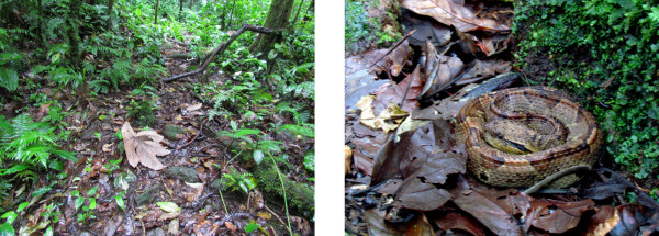
Hiking here was probably the only time I’ve ever been scared by a snake, at it was because I didn’t see it until my sport sandal was only about eight inches from landing smack on it. I ended up lunging forward. stretching my step another couple of feet straddling the thing, staring straight down at it between my legs while I tried to regain my balance and leap away.
Fortunately it was cool out and the little guy never even blinked – let alone jumped as its name implied it might. It was still in the exact same spot when we returned headed down the trail.
The Waterfalls

The first time we hike this trail we never saw the waterfall. After about 3 km the trail peters out and seems to dead end into a swirling pool that’s a nice spot to take a dip. The river curves out of sight into a sheer walled ravine to the right and there’s no way to follow the water upstream.
We poked around on both banks but couldn’t find an obvious way to proceed. We’d seen a lot of waterfalls and were worried we might not be able to spot the snake in the late afternoon light so we headed back only slightly disappointed.
We’ve returned several times since and discovered that the trail picks up again on the opposite bank, but you have to scramble over bare vertical rock for about 30 meters before the path reappears in the mud and leads up to a view point.

According to the owners of the Albergue Catarata there’s another even bigger more beautiful waterfall if you keep scrambling up the trail-less nearly vertical mud wall for another kilometer. Seems like there’s always another bigger more beautiful falls a bit further upstream in Costa Rica.
The Crater Trail
There is also a trail to the volcano crater but it is reserved for research scientist, requires an overnight stay, and is not open to the public. We’re working on getting permission (sometimes a PhD in biochemistry comes in handy for explorers) and will let you know what it’s like if we manage it.
Getting There and When to Visit

The PDF map download (see above) includes a zoomed out view showing the main ways to arrive in the area along with driving directions.
Bijagua is right on the continental divide but tends to have more wet Caribbean/Atlantic climatic association than dry Guanacaste. It’s always possible it’ll rain but pretty unlikely it’ll be drenching downpours for extended periods.
Use the drop down menu to see weather patterns and other seasonal information for the month you are thinking about visiting.
By the Way…

If you’re wondering how to get to the idyllic little hot springs pictured at the top of this article we’re sorry to say it’s no longer there. As part of Costa Rica’s drive for green energy (none of their electricity came from fossil fuels for the first two months of 2015 and they’re striving to make it permanent) they built a large geothermal power station that taps into the underground hot water to drive steam turbines.
That’s progress…I guess…
