I don’t know who coined the phrase “over the hill” but it seemed like an apt title for the tale of our trek across southern Costa Rica – from the Caribbean to the Pacific, up and over the Talamanca mountains and through La Amistad International Peace park.
When Sue and I turned the big five-oh we celebrated for a whole year doing stuff we’d always wished we could like Madrid, the beaches of southern Portugal, the Louvre and City of Lights… and walking coast to coast of the north American Continent. Admittedly at one of the narrowest points, but still a long walk.

I sent out word to everyone I knew and a few intrepid souls took up the challenge. Chris from northern California, Andy from Colorado, Justin from Arenal and Andres from San José all agreed to take ten days and help me celebrate being over the hill by going over a really big hill. They’re all younger so I can’t wait to see what adventures they dream up to drag me on when they each turn 50.
They say “a rolling stone gathers no moss.”
I’ll add “if you roll fast and hard enough you may even scrape off a little (along with some skin if you’re not careful).”

After Day 0 each of the titles in the summary below is linked to a separate post and photo album if you’d like to read the stories.
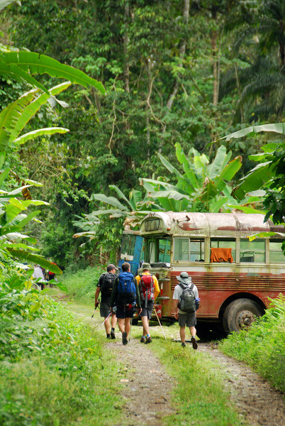
Day 0 – San José to Puerto Viejo de Talamanca
The day before we hit the trail was filled with logistics and picking up old friends from the airport. We covered every inch of floor and counter space in the three bedroom condo we’d rented by spreading out all the gear, food and supplies that different people had been responsible for bringing. Once it was all redistributed we packed up, kissed our wives and children goodbye and climbed in the shuttle van Justin arranged.
Traffic through San José was insane so we were late picking Andres up on the far side and traffic was even worse on the Guapiles highway through Braulio Carrillo National park to the Caribbean coast. I often comment on the roads and traffic in Costa Rica that “we could walk there faster” and quite often it’s true but in this case it was going to take us significantly longer to walk across the country than drive – no matter how slow the lumber truck in front of us was going.
It was after 11:00 when we rolled into Colin’s place at Banana Azul just north of Puerto Viejo on Playa Negra. Everyone just went straight to bed.
Day 1 – Puerto Viejo to Coroma
March 17 (St. Patrick’s Day)
Total – 40.3 km (25 miles), 504 meters (1,654 ft) elevation gain.
Mountain bike – Puerto Viejo to Suretka 29.6 km (18.4 miles), 447 meters (1,467 ft) elevation gain.
Boat – Suretka (Rio Telire) to Lari 6.1 km (3.8 miles), 5 meters (16 ft) elevation gain.
Hiking – Rio Lari to Coroma 4.6 km (2.9 miles), 52 meters (171 ft) elevation gain.
A relatively easy day warming up and getting to the trail head by mountain bikes, boats and on foot.
Day 2 – Coroma to Kichuguecha

March 18
Hiking – 13.7 km (7.8 miles), 529 meters (1,670 ft) elevation gain.
We followed the south bank of the Río Coén through the wide relatively flat Valle de Talamanca for most of the morning.
Day 3 – Kichuguecha to Quebrada Mari

March 19
Hiking – 11.6 km (7.2 miles), 467 meters (1,532 ft) elevation gain.
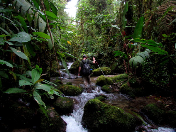
The first day in pure wilderness. The settlements and homesteads were all behind us and all that lay ahead was rain and cloud forest.
Day 4 – Quebrada Mari to Fila Bugu

March 20
Hiking – 9.9 km (6.2 miles), 913 meters (2,995 ft) elevation gain.
First a steep climb out of the the Río Coén valley, over the ridge on the west side of the Quebrada Yobri drainage then down to the Río Tapari – a major tributary of the Coén which we’d been told we’d need ropes to cross. After that we left the Río Coén drainage and headed straight up Cuesta Bugú and the rest of the trek would be in the highlands.
Day 5 – Fila Bugu to Catarata Ririgu
March 21
Hiking – 15.5 km (9.6 miles), 936 meters (3,071 ft) elevation gain.
Long slow climb along the 2,000 meter high ridge (Fila Bugú) that separates the drainage of the Río Coén from the Tapari. After crossing high points at Alta Chinegucha, Surisan, Buikuari and Cerro Carguicacha we dropped back down to the Río Coén; now more like a stream 1,100 meters above where we’d last crossed.
Day 6 – Catarata Ririgu to Rio Lori

March 22
Hiking – 7.5 km (4.7 miles), 467 meters (1,532 ft) elevation gain.
Slept in and messed around with a side hike to a waterfall and took a fall down another this morning. Didn’t leave camp until around 7:20 a.m. because it would be a short easy day.
Day 7 – Rio Lori to Ujarras

March 23
Hiking – 19.5 km (12.1 miles), 615 meters (2,018 ft) elevation gain, 1,933 meters (6,341 ft) elevation loss.
Got out of camp around 6:30 a.m. and hit the trail to climb to the continental divide, over the top and down the other side back to civilization where hopefully our next outfitter would meet us.
Day 8 – Ujarras to Cordoncillo

March 24
Mountain bike – 43.4 km (22.6 miles), 678 meters (2,224 ft) elevation gain.
The porters and guides caught a bus to the beach then on to San José and back to the Caribbean.
You’ll probably notice a significant drop-off in the quality of the pictures for the next few days. Andres is a professional photographer and took many of the best shots in the first week but his feet had turned into hamburger inside his mountaineering boots. As soon as we reached a road he headed to the nearest clinic then back to San José to recuperate.
Day 9 – Cordoncillo to La Gran Vista

March 25
Mountain bike – 36.8 km (22.4 miles), 618 meters (2,028 ft) elevation gain.
We had to ride a short segment of the Pan American because you can’t cross Costa Rica without crossing it. Riding on Highway 1 is a scary proposition but we went early in the morning and only had to cover a few km.
Day 10 – La Gran Vista to Playa Hermosa

March 26
Mountain bike – 31.7 km (19.7 miles), 867 meters (2,844 ft) elevation gain, 1,562 meters (5,124 ft) elevation loss.
There was a relaxed feel about the ride today. We knew it was all downhill (except for the uphill parts) and there was a beautiful beach (literally Playa Hermosa – one of a half dozen in Costa Rica) waiting for us at the bottom. We had a swimming pool, hammocks, a couple of cabins and family waiting at Hacienda Barú just up the coast and Jack always has cold beer in the fridge.