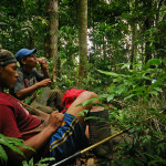
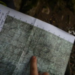
There are two reasons we won't just send you the gpx files to load into your Garmin so you can solo this trek In order to enter or cross the indigenous reserves you need the blessing of the people who own them. This means you'll be accompanied by a baquiano and won't need a GPS. The last … [Read more...]
Over the Hill
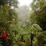
I don't know who coined the phrase "over the hill" but it seemed like an apt title for the tale of our trek across southern Costa Rica - from the Caribbean to the Pacific, up and over the Talamanca mountains and through La Amistad International Peace park. When Sue and I turned the big five-oh we … [Read more...]
Puerto Viejo to Coroma
Day 1 - March 17 (St. Patrick's Day) Total - 40.3 km (25 miles), 504 meters (1,654 ft) elevation gain. Mountain bike - Puerto Viejo to Suretka 29.6 km (18.4 miles), 447 meters (1,467 ft) elevation gain. Boat - Suretka (Rio Telire) to Lari 6.1 km (3.8 miles), 5 meters (16 ft) elevation … [Read more...]
Coroma to Kichuguecha
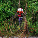
Day 2 - March 18 Hiking - 13.7 km (7.8 miles), 529 meters (1,670 ft) elevation gain. We followed the south bank of the Río Coén through the wide relatively flat Valle de Talamanca for most of the morning. Packing Up and Heading Out Our packs were smaller and lighter than the porters. It … [Read more...]
Kichuguecha to Quebrada Mari
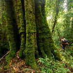
Day 3 - March 19 Hiking - 11.6 km (7.2 miles), 467 meters (1,532 ft) elevation gain. Kichuguecha Not that Coroma was a metropolis (no stores, offices or really anything but gardens and houses) but Kichuguecha was as close as you could get to nothing and still be something. The only building is … [Read more...]
Quebrada Mari to Fila Bugu
Day 4 - March 20 Hiking - 9.9 km (6.2 miles), 913 meters (2,995 ft) elevation gain. First a steep climb out of the the Río Coén valley, over the ridge on the west side of the Quebrada Yobri drainage then down to the Río Tapari - a major tributary of the Coén which we'd been told we'd need … [Read more...]
Fila Bugu to Catarata Ririgu
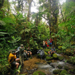
Day 5 - March 21 Hiking - 15.5 km (9.6 miles), 936 meters (3,071 ft) elevation gain. Long slow climb along the 2,000 meter high ridge (Fila Bugú) that separates the drainage of the Río Coén from the Tapari. After crossing high points at Alta Chinegucha, Surisan, Buikuari and Cerro … [Read more...]
Catarata Ririgu to Rio Lori
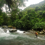
Day 6 - March 22 Hiking - 7.5 km (4.7 miles), 467 meters (1,532 ft) elevation gain. Slept in and messed around this morning. Didn't leave camp until around 7:20 a.m. because it would be a short easy day. Water Fall There was a tradition on the Outward Bound course I took in Colorado 33 … [Read more...]
Rio Lori to Ujarras
Day 7 - March 23 Hiking - 19.5 km (12.1 miles), 615 meters (2,018 ft) elevation gain, 1,933 meters (6,341 ft) elevation loss. Got out of camp around 6:30 a.m. The Continental Divide The last day on foot was the longest distance, a big climb and the most elevation loss (which is actually … [Read more...]
Ujarras to Cordoncillo

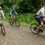
Day 8 - March 24 Mountain bike - 43.4 km (22.6 miles), 678 meters (2,224 ft) elevation gain. The porters and guides caught a bus to the beach then on to San José and back to the Caribbean. You'll probably notice a significant drop-off in the quality of the pictures for the next few days. … [Read more...]
Cordoncillo to La Gran Vista

Day 9 - March 25 Mountain bike - 36.8 km (22.4 miles), 618 meters (2,028 ft) elevation gain. We had to ride a short segment of the Pan American because you can't cross Costa Rica without crossing it. Riding on Highway 1 is a scary proposition but we went early in the morning and only had to … [Read more...]
La Gran Vista to Playa Hermosa

Day 10 - March 26 Mountain bike - 31.7 km (19.7 miles), 867 meters (2,844 ft) elevation gain, 1,562 meters (5,124 ft) elevation loss. There was a relaxed feel about the ride today. We knew it was all downhill (except for the uphill parts) and there was a beautiful beach (literally Playa … [Read more...]
Meals & Gear Transcontinental
Community Gear List Back country food/cooking for eight days (see meals below for grocery list) 8 dinners (RAY – 4, ANDY – 3, CHRIS - 1) Water filters (RAY - MSR micro) (CHRIS - second filter) Chemical/peroxide water system (RAY) Water bag 20L this is so we can filter in camp instead of … [Read more...]