Note: The sidewalk widening on the Río Tárcoles bridge (see details) that has been snarling Pacific Coast beach traffic since December is scheduled for completion in March 2020.
reroute to hell | beach traffic | free GPS | coverage
Instant information on traffic conditions is especially helpful when traveling in Costa Rica because there aren’t that many ways to get from point A to point B. Going around a landslide could easily add five or six hours to a two hour drive.
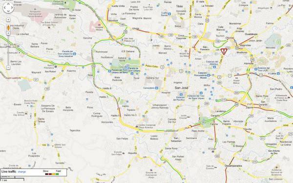
Instant updates on jams and slow moving vehicles are available on smartphones or on the internet using this map from WAZE and now you can even use WAZE in offline mode so you don’t have to pay for international roaming cell phone data.
Check traffic congestion before you head to the airport or make a trip to the beach.

reroute to hell | beach traffic | free GPS | coverage
“Rerouting…”
Waze is quite good at finding the way around traffic congestion and road closures but there are a couple of things to keep in mind when you hear the calm confident voice say “re-routing.”
- There are not a lot of “extra” roads in Costa Rica so going around may mean way around. It’s not uncommon for an alternate route to add several hours to the drive time but WAZE won’t mention it….take a look before blindly following “re-routing – turn right in 100 feet.”
- There are some insanely bad roads in common use in Costa Rica and especially on alternative routes we’ve found ourselves locked into 4WD low, sliding down an inescapable boulder strewn ravine bottom just praying that there’s a way out because there’s definitely nowhere to turn around… WAZE does learn what’s passable and what is not based on whether other drivers have gone that way but those other drivers may well be absolute maniacs.
Bad roads aren’t the only hazard lurking on Costa Rica’s less traveled routes. Bad neighborhoods (think of the stripped family truckster surrounded by thugs in National Lampoon’s “Vacation”) are a problem in and around (but not strictly limited to) San José, Limón and Puntarenas especially after dark.
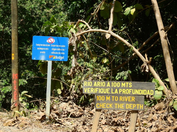
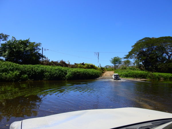
Another hazard that you may never encounter at home is a river ford (see how to ford a river in your vehicle). Again, WAZE won’t mention it and the first you’ll know is when you see the sign announcing that your rental car insurance is void if you proceed.


reroute to hell | beach traffic | free GPS | coverage
Coverage in Costa Rica
For crowd-sourcing to be effective you need a crowd contributing data in real time and while cell phones are almost ubiquitous in Costa Rica signal is not.
There are some stretches of a number of Costa Rican roads that have no cell service which means they are effectively invisible to WAZE traffic updates.
There could be 100 cars sitting perfectly still on the Guapiles Highway in the mountains of Braulio Carrillo (and frequently are with the construction there) and WAZE would show no problem because none of the phones have signal to update WAZE. It will be interesting to see how good the construction delay info is based only on users comments instead of phone data when a Chinese construction firm begins work to expand that road to four lanes in 2018 until 2021.
Another Option
The transit police maintain a web based list of updates which includes landslides, washed out bridges and other delays/closures on major routes. They do a good job of keeping the road information up to date for a few major routes but unfortunately the website is frequently down for days or weeks at a time.
It is in Spanish. You can try dropping the url into Google Translate or another Spanish to English app but they use a lot of vernacular and usually the English version is less intelligible than the original.
reroute to hell | beach traffic | free GPS | coverage
Weekend Beach Traffic
Highway 27 “The Caldera” was more than 25 years in the making and all 40 km (25 miles) was planned as a 100 kph, four lane, limited access divided super highway to the Pacific. Unfortunately most of it ended up as just another two lane road and the capacity is woefully inadequate to handle the traffic between the beaches and the central valley.

There are over 3 million people living in and around San José and it seems like every one of them is on the road to the beach every Friday, especially in dry season. It’s even worse in the other direction on Sunday afternoon when everyone heads home.
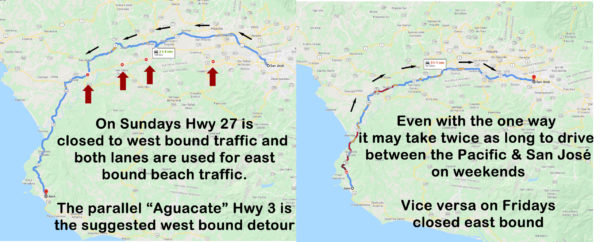
For about six years the highway department has been alleviating some of the congestion that lead to delays of several hours by making Hwy 27 one way beach bound on Friday and one way San José bound on Sundays.
We strongly recommend you avoid traveling either direction on Friday and Sunday afternoons. The detour on Hwy 3 “The Aguacate” is narrow, winding, steep and longer adding between 40 minutes and an hour in the “light traffic” direction. The main highway 27 may doubles capacity with all lanes one way but it’s not nearly enough and there can be hours of slow and go.
reroute to hell | beach traffic | free GPS | coverage
Quick Links Slowdown Locations
Note: The trucker strike (huelga) and protest “marches”/road blocks (see strike explained) that caused up to 10 hour delays around Costa Rica have officially ended.
We compiled this list of routes during the trucker blockades protesting the new tax laws that came into effect in 2019. The blockades are over but the links are still helpful to jump to various routes to check for accidents etc. We’re also keeping them around because protests are a long tradition and there will be new roadblocks someday.
The red (blocked), yellow (slow) and green (normal) indicate the status at the most common roadblock locations last time we looked. The “check current roadblock status” links will take you to the Waze livemap for an instant update.
- ██ Hwy 1 the PanAmerican at Airport Blvd (check current roadblock status). Earlier taxis were blocking Airport Blvd but by lunch time Waze is indicating traffic moving normally.
- ██ Hwy 1 the PanAmerican at Naranjo (check current roadblock status)
- ██ Hwy 1 the PanAmerican at Palmares (check current roadblock status)
- ██ Hwy 1 the PanAmerican at San Ramón (check current roadblock status)
- ██ Hwy 1 the PanAmerican at Liberia (check current roadblock status)
- ██ Hwy 27 at La Garita bridge over the Río Grande (check current roadblock status)
- ██ Hwy 27 at Orotina (check current roadblock status)
- ██ Hwy 27 at the bridge over the Río Jesús María east pf Caldera (check current roadblock status)
- ██ Hwy 34 the Costanera Pacific Coast Highway in Parrita (check current roadblock status)
- ██ Hwy 34 the Costanera Pacific Coast Highway at Quepos/Manuel Antonio (check current roadblock status)
- ██ Hwy 34 the Costanera Pacific Coast Highway in Uvita (check current roadblock status)
- ██ Hwy 2 Pan American Highway in San Isidro de el General/Perez Zeledon and the alternate bridge over the Río San Isidro on airport road (check current roadblocks status)
- ██ Hwy 2 Pan American Highway at Río San Pedro/Fortuna south of San Isidro de el General/Perez Zeledon (check current roadblocks status)
- ██ Hwy 2 Pan American Highway at Palmar on the bridge over the Río Térraba blocking all travel to the Osa and southern zone (check current roadblocks status)
- ██ Hwy 2 Pan American Highway at Río Claro blocking travel to Golfito (check current roadblocks status)
- ██ Hwy 32 and Hwy 4 at the bridge over the Río Sucio (check current roadblock status)
- ██ Hwy 32 in Guácimo (check current roadblock status)
- ██ Hwy 32 Liverpool near Limón (check current roadblock status)
- ██ Route 10 west of Siquirres (check current roadblock status). If you’re traveling between the Caribbean and San José the normal detour is route 10 via Turrialba but it is also blocked near Siquirres
- ██ Route 141 (San José to Arenal) at San Carlos/Cuidad Quesada (check current roadblock status)
- ██ Route 140 (San José or Caribbean to Arenal) at Aguas Zarcas (check current roadblock status) bridge over the Río Aguas Zarcas
- ██ Hwy 4 (Caribbean to Arenal) at Vuelta de Kooper (check current roadblock status) bridge over the Río Aguas Zarcas
- ██ Hwy 4 (Arenal to the north Pacific) at Río Arenal (check current roadblock status) bridge over the Río Arenal
- ██ Hwy 4 and Hwy 35 at Muelle (check current roadblock status) -rockpile
- ██ Hwy 4 and Hwy 6 at Upala (check current roadblock status)
- ██ Route 126 and Route 140 at San Miguel (check current roadblock status) – rockpile
- ██ Route 160 Santa Cecilia/Paquera blocking ferry traffic from Puntarenas to the Nicoya Peninsula (check current roadblock status) – junk cars and tires
Officials for the truckers union and the church released an announcement stating “Pedimos disculpas al pueblo de Costa Rica y al sector productivo por los daños ocasionados”, “we apologize to the people and businesses of Costa Rica for the damage caused” as they announced that they would abandon the roadblocks and return to the negotiating table.
According to the truckers representatives slow or stop and go is just the normal Costa Rican traffic not an intentional tortuguismo.
Free real time traffic and congestion maps using phone GPS data crowd sourcing in Costa Rica
The WAZE app is a popular Google navigation product which gives directions, tracks phones positions in real time and allows users to pin comments on police speed traps, construction, accidents and other delays. (details on how it works).
reroute to hell | beach traffic | free GPS | coverage
