Costa Rica Guide

travel information and maps

  • Vacation Planning
  • Best Trips Ever>>
  • More Fun Than Humanly Possible
  • Costa Rica
    • Top Ten
    • Best Time to Visit Costa Rica
    • Things To Do in Costa Rica
    • Maps
    • Transportation
      • Rental Cars
        • Advantages of Driving
        • Disadvantages Driving
        • Code of the Road
        • Navigation & Drive Time
        • Rental Insurance Explained
        • Can’t Get There
      • Airports
        • Flights Worth Taking
        • LIR or SJO
        • Airfare Deals
        • Domestic Airlines
        • Domestic Air Tips
      • Taxis
      • Bus Schedule
    • Food
      • Typical Menu
      • Batidos & Refrescos
      • Gallo Pinto
      • Tamales
      • Ceviche
      • Ensalada Palmito
      • Sopa Negra
      • Vinagre Chilera
    • Weather
      • Seasons in Costa Rica
      • Current Storms in Costa Rica
    • Regions
  • Nature & Wildlife
    • National Parks
    • Wildlife Refuges
    • Ecozones
    • Best Places to See Wildlife in Costa Rica
  • Practical Info
    • Health & Safety
      • Health Tips
        • Altitude Sickness
        • Chikungunya
        • Natural Disasters
      • Crime
        • Cons & Rip-offs
        • Corruption
        • Violent Crime
    • Will My Phone Work?
    • Packing List
    • Passports & Docs
    • Money – How To?
    • How Much Does it Cost?
    • Travel Tips
  • Stories
    • Photos
    • Trek Across Costa Rica
    • Sendero de Oro
    • Quebrada Gata
    • Bicycle Touring
    • About Us
  • Move to Costa Rica
  • Free Travel Pack
no obligation custom trip plan & price quote

1-866-816-0197

· Copyright © 2023 ·

Pacific – 2 – Quepos, Manuel Antonio, Uvita

1999 Central Pacific bicycle tour

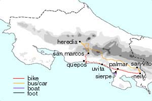
Quepos -> Manuel Antonio -> Quepos -> Punta Uvita

We spent two nights in Quepos, and rode out to Manuel Antonio National Park to hike in the intervening day. The park is considered a jewel of the system in Costa Rica. The access road in is paved, there are hotels, restaurants and bars within easy walking distance and approximately 13 km of well developed and maintained trails, and undeveloped beaches to walk on.

Manuel Antonio trail

In spite of the surrounding development and heavy use (admission is limited so get there early), the park is quite nice. The beaches are beautiful (even if they are the most crowded walk in beaches in Costa Rica) and if you choose to walk the trails, you will discover that 90% of the people in the park stay on the beach.

The road south from Quepos to Uvita is one of the worst that is considered more than a cart path by map makers.

Parts of it are in the midst of being paved, but when we talked to the locals about when they thought it would be finished, they laughed and said “It’s supposed to be done by last Christmas.” Much of it is round rock road and the going is slow for vehicles and bicycles alike. However, the area makes up for what the road lacks.

Rancho Merced Wildlife refuge just outside of Uvita was one of the best examples we saw of ecotourism working on a local level. Since we weren’t doing any investigative reporting, we didn’t gather any data on the economic impact or employment opportunities provided by the rancho.

It was apparent though, that the tourists were spending their money with local businesses and not multinational corporations. Apparent because there were no corporate hotels, restaurants or tour companies around.

Ray & Sue

Cost · ToDo · Plan·Costa Rica Guide logo animated·Top10 · Best Time · Contact


toll free Costa Rica travel desk!
1-866-816-0197

CONTACT US

1999 South Pacific Tour
  • Pacific – 5 – Palmar to San Vito
  • Pacific – 4 – Ballena, Palmar & Sierpe
  • Pacific – 3 – Uvita & Ballena
  • Pacific – 2 – Quepos, Manuel Antonio, Uvita
  • Pacific – 1 – San Marcos & Quepos


Costa Rica Guide on facebook
Costa Rica Guide on Facebook